
Cyclone Akvan is moving towards the eastern coast of India, and Andhra Pradesh and Odisha are worried as the IMD predicts that the severe cyclonic storm will make landfall around noon on November 20.
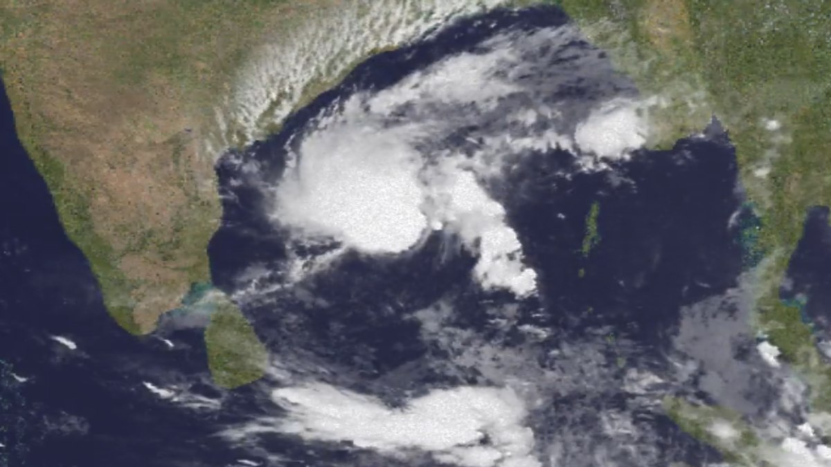
The weather bulletin issued today said that the cyclone would cross North Andhra Pradesh, Yanam and South Odisha coasts between Narsapur and Puri. Weather warnings have been issued for coastal areas as the storm approaches, and authorities are keeping a close watch on its movement and intensity.
Maximum sustained wind speed during landfall is predicted at 90–100 kmph while gusts may reach up to 110 kmph. People in vulnerable coastal areas have been asked to stay alert and follow official weather updates as the situation develops.
The severe cyclonic storm formed over the central parts of the South Bay of Bengal and adjoining Westcentral Bay of Bengal. It has been moving north-northwestward and is approaching the eastern coastline.
As per the IMD bulletin for today, the system was about 540 km southeast of Narsapur in Andhra Pradesh; 570 km east of Chennai; 600 km south-southeast of Kalingapatnam and around 690 km south of Gopalpur in Odisha at 11:30 am on November 18. The system moved at a speed of about 8 kmph during the last six hours. Meteorologists are keeping a close watch on its movement because changes in direction and intensity could affect areas most likely to be affected.
One of the major concerns with Cyclone Akvan is extremely heavy rainfall in coastal Andhra Pradesh, Yanam and Odisha. The weather department has said that isolated places in these areas could receive extremely heavy rainfall on November 19 and 20 under the influence of Cyclone Akvan.
Heavy rain may cause waterlogging, flooding in low-lying areas, disruption in road transportation and problems for people living in vulnerable coastal settlements. Strong winds could also damage electricity infrastructure, trees, temporary structures, and other public facilities. People should take precautionary measures and avoid unnecessary travel during severe weather conditions.
The landfall location has also been changed in successive IMD bulletins. Earlier bulletins said the cyclone could cross Andhra Pradesh and Yanam coastline between Nellore and Visakhapatnam, but the latest national bulletin on November 18 extended the forecast landfall stretch northwards, likely crossing the area between Narsapur in Andhra Pradesh and Puri in Odisha.
So several coastal districts in both states need to watch out for the latest forecasts closely. The point of landfall may become clearer as the cyclone approaches the coast, but don’t rely on old forecast maps or unverified information spread on social media.
Odisha and Andhra Pradesh administrations will step up preparedness as the storm approaches. District authorities in vulnerable districts should watch rainfall forecasts, identify low-lying settlements, prepare emergency response plans and ensure essential services are available.
Fishermen and people involved in marine activities should pay special attention to official warnings on sea conditions and restrictions on going into the sea; coastal residents should secure loose objects around their homes; medicines and important documents must be ready at home; nearby safe shelters should be identified if evacuation is ordered; people living in flood-prone areas should avoid crossing overflowing roads, streams and drainage channels.
The cyclone’s approach has also worried people about disruption to transportation, fishing activities, agriculture and daily life in the affected regions. Heavy rain may damage standing crops while strong winds could damage plantations and temporary agricultural structures; fishing communities are among groups which may face severe difficulties due to rough sea conditions and restrictions on fishing.
Local administrations and disaster management teams will have to coordinate precautionary measures so as not to overburden vulnerable communities. Travellers planning journeys to coastal Andhra Pradesh and Odisha should check weather and transport advisories before starting their trips.
Cyclone Akvan is expected to reach the coast around noon on November 20, and the next 48 hours are crucial for tracking movement and impact assessment. IMD will issue updates on the intensity of the cyclone, landfall location, rainfall distribution and wind speed, etc in the next 48 hours.
People of Andhra Pradesh, Yanam and Odisha should follow bulletins from the weather department and instructions given by local authorities. Exact impact will depend on cyclone movement and intensity at landfall, but early preparedness and adherence to safety advisories will reduce risks to life and property.





Comments