
A strong earthquake of magnitude 7.2 struck the Pacific Ocean near Vanuatu on 24 October 2026 and the Pacific Tsunami Warning Centre in Hawaii issued a tsunami warning to coastal areas within 300 km from the epicentre of the earthquake and coastal communities about 300 km from the epicentre in the Pacific Ocean for a tsunami warning and warnings were issued.
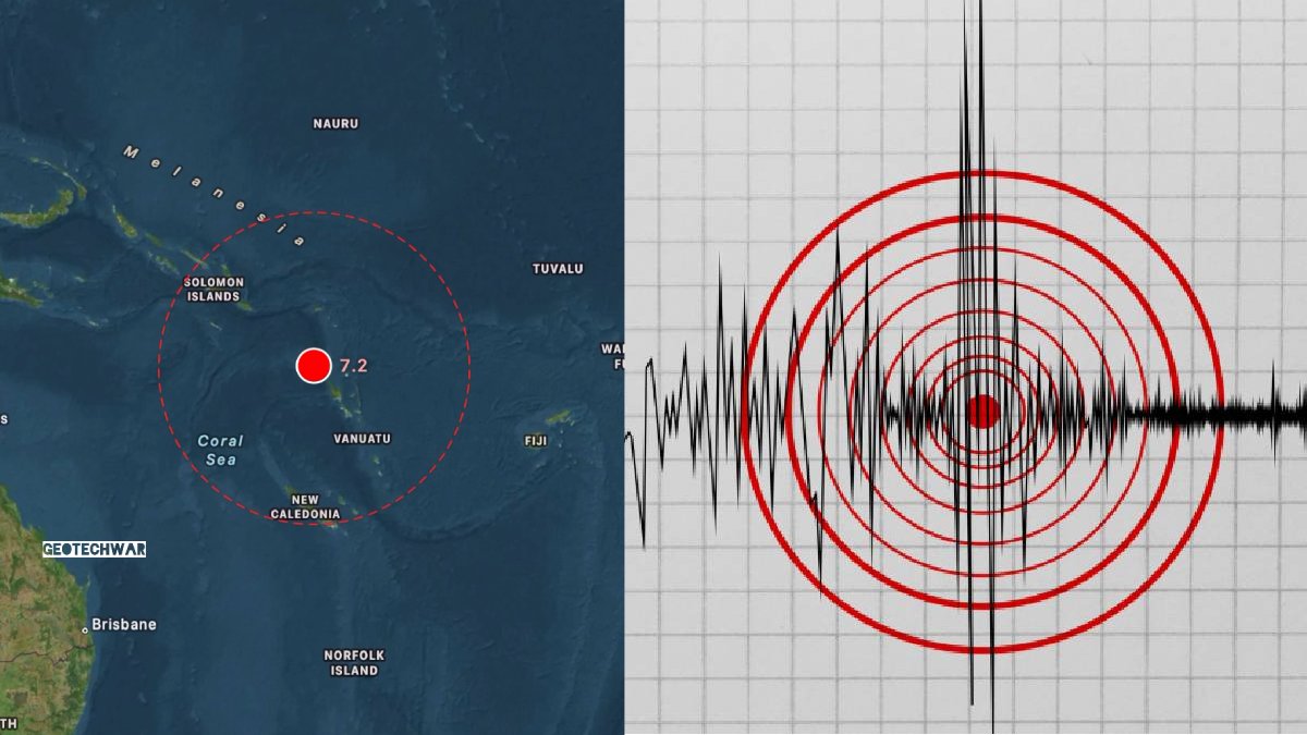
The strong undersea earthquake caused officials to issue warnings and monitor the threat of dangerous tsunami waves to the islands and coastal areas and people who are far away. The earthquake was reported to be 200 km west of Sola, Vanuatu, at a depth of about 10 km below the ocean surface, and the Pacific Tsunami Warning Centre in Hawaii issued a warning about the earthquake and how waves could reach those areas.
Earthquake Strikes Near Vanuatu
The earthquake happened at 2:31 a.m. UTC on Saturday, according to initial reports. The shallow depth of the earthquake increased fears of tsunami activity, as strong undersea earthquakes can dislodge large quantities of water and produce waves that can reach nearby coastal areas.
The USGS initially reported the earthquake as magnitude 7.2. But measurements of earthquakes can change as seismic monitoring agencies evaluate more data from monitoring stations. Some reports indicate the magnitude was changed later on, and it is important to follow up with the official update in the first hours after a major earthquake.
The epicentre was about 200 kilometres west of Sola, a settlement in Vanuatu. The earthquake happened in the Pacific Ocean, far away from the main populated areas, but the magnitude and shallow depth of the earthquake led authorities to issue precautionary warnings for nearby coastal areas.
A 6.9-7.2 magnitude shallow earthquake struck the Vanuatu Islands region at 13:31 local time. Officials issued a localized tsunami warning, advising that hazardous waves could impact coasts located within 300 km of the epicenter. #séisme - Sismo - Terremoto - Temblor https://t.co/zk2DkTgew3
— GeoTechWar (@geotechwar) October 24, 2026
They said a second strong earthquake also occurred in the area, and there was more seismic activity. The authorities and monitoring agencies were monitoring the situation so that warnings or protective measures would be needed.
Tsunami Warning Issued for Coastal Areas Within 300 Kilometres
After the earthquake, the Pacific Tsunami Warning Centre issued a warning that potentially dangerous tsunami waves could affect coastlines within 300 kilometres of the epicentre.
The warning covered areas in the vicinity of the earthquake zone where coastal communities could be at higher risk from unusual sea level shifts, strong currents and potentially dangerous waves.
According to initial reports, the first tsunami wave was expected to reach Espiritu Santo, one of Vanuatu’s major islands, at 3:01 a.m. UTC. But officials said arrival times would vary depending on the location and conditions.
There is also an important aspect of tsunami warnings: the first wave may not be the biggest. Subsequent waves can arrive after the initial disturbance and may continue posing dangers even when the sea appears relatively calm.
Tsunami effects can differ dramatically by coastal geography, underwater terrain, water depth and tides. Even small waves can generate dangerous currents in harbours, bays and narrow coastal passes.
Residents of affected areas should listen to official announcements and follow emergency management authorities’ instructions. Coastal residents should observe the sea and not enter the water.
The warning was made to ensure that the earthquake’s effects and the possibility of tsunami waves moving across the Pacific were taken into account by monitoring agencies.
No Immediate Reports of Major Damage or Casualties
There were no deaths, injuries or severe property damage reported at the time of the earthquake (as of 8:26 p.m. in Kolkata) at that time.
But authorities were still assessing the situation, and the absence of immediate reports did not necessarily mean that all affected areas had been checked.
Vanuatu has many islands in the South Pacific Ocean. The country’s geography makes it challenging for emergency response teams when strong earthquakes occur offshore, and warnings cover multiple coastal communities.
In some cases, communication systems, transportation networks, and access to remote islands can have a direct impact on how quickly authorities get information about possible damage.
The earthquake’s offshore location could have diminished its immediate effects on the populated areas in the region, but the tsunami warning still presented a threat to all those on the coastline near the affected waters.
Emergency authorities would continue monitoring seismic activity, assessing tsunami observations, and issuing updates as soon as new information was available.
Residents were encouraged to rely on official emergency announcements rather than unverified information circulating on social media.
The situation was still fluid during that first reporting period, and more information on possible damage, injuries, and tsunami impacts is expected to be available as assessments continue.
Vanuatu Located in the Pacific Ring of Fire
Vanuatu is an island nation in the South Pacific Ocean, east of Australia and west of Fiji. It is made up of about 80 islands and is located in a region of frequent earthquakes and volcanic activity.
The archipelago is in the larger Pacific Ring of Fire, a vast zone of active tectonic boundaries, volcanic deposits and frequent seismic activity.
Earthquakes happen in this region because tectonic plates of the Earth move and interact beneath the Earth's surface. Those movements can cause very strong seismic disturbances when one tectonic plate moves beneath another.
Vanuatu’s location makes earthquake preparedness and tsunami monitoring a key component of disaster management efforts in the country.
Strong undersea earthquakes can create tsunami waves if they cause a large vertical displacement of the ocean floor. But not every powerful earthquake generates a destructive tsunami, and the actual effects depend on several geological and oceanographic factors.
The earthquake once more reinforced that regional monitoring systems are important, as are international coordination and public awareness in countries affected by natural disasters. The situation is being monitored.
The earthquake and tsunami warning triggered continued monitoring by seismic and tsunami warning agencies.
Based on current information, scientists were assessing if the warning would be lifted, extended or modified based on observed sea-level changes and updated earthquake measurements.
Coastal residents were advised to remain cautious until officials verified the threat had passed.
Emergency officials usually assess tsunami risk by seismic measurements, ocean monitoring instruments and observations from coastal locations. These systems help determine if dangerous waves have been generated and whether they are approaching vulnerable areas.
Such an earthquake can occur with little warning in areas along active tectonic boundaries.
As the situation develops, further updates are expected regarding the earthquake's final magnitude, the status of the tsunami warning, and any possible impact on Vanuatu and neighbouring coastal communities.





Comments
Leave a Comment