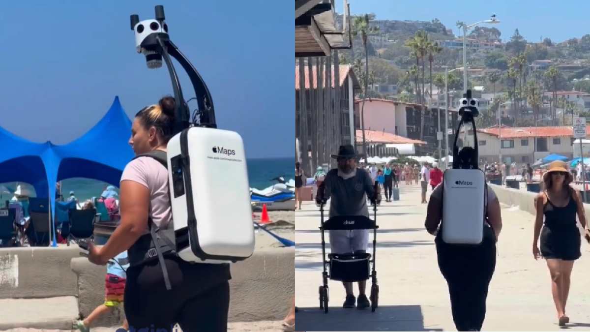
Apple is mapping the world differently sending people out on foot to places where cars and other mapping vehicles can’t easily go. So it is also equipped with special backpacks with 360-degree cameras that can capture city streets, walking paths and remote locations.
The initiative shows how digital maps are increasingly moving beyond roads. While mapping vehicles can cover large areas quickly, they are limited when it comes to narrow pathways, pedestrian-only routes, parks, stairways and other locations that cannot be reached by cars.
Mapping Places Cars Cannot Reach
People involved in Apple’s mapping efforts carry backpacks equipped with cameras and other equipment. The systems collect images as they move through areas to ensure the map coverage and location information are provided.
The approach is particularly useful in places where traditional vehicles have limited access. Pedestrian paths, trails, campuses, parks and narrow lanes can be difficult to capture using conventional mapping cars.
So the imagery gathered can help Apple update its map data and give users an accurate picture of the locations in which they can see on foot.
Why 360-Degree Cameras Matter
The use of 360-degree cameras allows mapping teams to see everything from multiple angles while moving around the area. Instead of simply recording what’s on the ground in front of a person that’s carrying the camera and moving things, the cameras can record more than just what’s in front of the person carrying the equipment; the cameras are able to capture the whole environment.
This type of data can be useful for navigation and digital maps to better represent pedestrian routes.
For users, better foot-level mapping could make navigation more useful in places where driving directions are not enough. Someone walking through a park, tourist destination or pedestrian-only area could benefit from map information gathered directly from those pathways.
Apple, insanlara dünyayı yürüyerek haritalandırmaları için ödeme yapıyor.
— etginlik (@etginlik) August 20, 2026
▬ İnsanlar, 360 derece kameralarla donatılmış çantalar taşıyarak araçların ulaşamadığı sokakları, patikaları ve uzak noktaları haritalıyor.
▬ Bu çalışmalar sayesinde yaya olarak erişilebilen bölgelerdeki… pic.twitter.com/G05pLmf51O
A human-powered approach to digital mapping
Although a lot of the mapping technology is based on satellites, vehicles, smartphones and automated systems, people are still key in gathering geographic information.
And walking-based mapping can fill gaps that large vehicles cannot. It also demonstrates how mapping companies are expanding their focus from simply connecting roads to creating a more complete digital representation of the world.
The work might involve long hours of walking while carrying specialized equipment, but the resulting images can contribute to better map coverage in areas that are otherwise very difficult to document.
What it means for the future of Maps
As digital navigation becomes a part of everyday life, accurate map data is becoming increasingly important. Maps of the pedestrian route could be useful for walkers, tourists, cyclists and people who are making their way to another city.
Apple's walking-based mapping efforts show that the world's digital maps don’t always require a car. Sometimes the best way to map a place is simply to walk through it.