A dramatic landslide filmed in the Kumaon region of Uttarakhand has drawn attention to the explosive geological forces shaping the Himalayan foothills. Some satellite imagery shows a large section of a mountain slope collapsing onto the ground, with soil, rock, and debris falling down the slope.
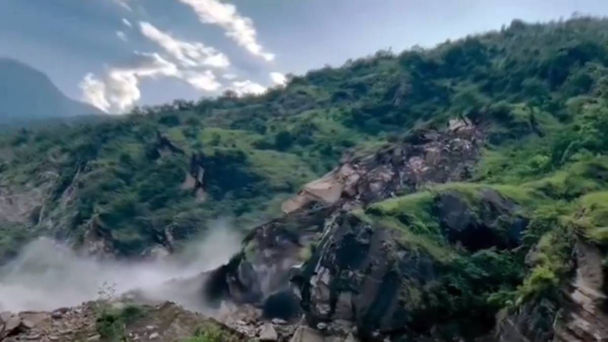
In such footage, it is natural to imagine that the entire mountain is suddenly unstable, but landslides are part of the history of the Himalayas. The region is one of the world’s most tectonically active mountain belts where the Indian Plate is still converging with the Eurasian Plate. Recent geological studies have documented the continued crustal shortening and active deformation of major structures, such as the Himalayan Frontal Thrust in the Kumaon region.
The Himalayas are thus not static mountains. They are constantly being uplifted, fractured, eroded and reshaped. And that long-term geological activity causes some slopes to become unstable.
One important factor is the structure of the underlying rock. Uttarakhand geological studies have revealed significant deformation and fracturing of rocks where there are major thrust faults and geological lines of succession. Weak or heavily fractured rocks can be especially susceptible to mass movement in steep terrain when external triggers such as intense rainfall or earthquakes occur.
Water is another major trigger. During periods of heavy or prolonged rainfall, water can penetrate cracks and soil layers, and so increase the pressure of pore water and diminish the strength of a slope. Saturated soil and weathered rock can then begin moving downhill under gravity.
This is particularly important during intense monsoon rainfall in the Himalayan region. Recent Uttarakhand disasters have been identified by scientific research as a combination of steep slopes, torrential rainfall, narrow valleys and human activities causing catastrophic debris flows and landslides.
This shocking footage from the Kumaon division in the Himalayan foothills shows a massive landslide in progress, with huge sections of the mountainside collapsing and moving before people's eyes
— Surajit (@surajit_ghosh2) October 1, 2026
What's happening beneath the Himalayas? pic.twitter.com/bC6Hxb42An
Earthquakes and smaller seismic movements can also contribute to slope instability. As the Himalayan region continues to undergo tectonic activity, the scientists who have studied previous disasters in Uttarakhand have found evidence that seismic processes can contribute to the destabilisation of rock and ice masses.
Another factor gaining increasing attention is the changing climate in high mountain regions. Rising temperatures can lead to glacier retreat and changes in snow and ice. In some places, melting ice can remove support from unstable slopes and changing rainfall patterns can increase the chance of intense precipitation-triggered landslides. Scientists do not want to assign any landslide in a particular place to climate change without considering the particular trigger and geological conditions at the site.
The wider Himalayan region has witnessed several spectacular slope failures in recent years. In September 2026, a major landslide in Nepal's Manang district sent a mountainside into the Marsyangdi River through continuous heavy rainfall. Scientists studying Himalayan disasters also have documented the interaction between glaciers, rock instability, rainfall, and seismic processes.
The Kumaon region itself has a complex geological history. Studies of the Himalayan Frontal Thrust indicate that it still allows for convergence between Indian and Eurasian plates, and that deformation is still happening just below the surface. Recent trends in convergence of Kumaon are estimated to be about 16-18 millimetres per year.
That does not mean that the ground beneath the region is going to collapse for no reason. Rather, it means that geological stresses accumulate and are released through a variety of processes over vastly different timescales. Most of the time these processes are invisible. Occasionally, though, rainfall, erosion, earthquakes or changes in groundwater conditions can push an already vulnerable slope out of its stability zone.
The most immediate concern following a large landslide is not necessarily what is happening deep beneath the entire Himalayan range, but whether the particular slope remains unstable. Fresh cracks, additional rockfalls, blocked roads, unstable debris, and rivers obstructed by landslide material can create secondary hazards.
As a result, authorities and residents in mountainous areas need to monitor slopes after large failures, rather than assuming that the first collapse will be the end of the event. Satellite imagery, geological surveys, rainfall monitoring, seismic networks and ground-based observations can all help to identify the areas where more movement might occur.
The dramatic Kumaon footage is ultimately a reminder of the extraordinary geological dynamism of the Himalayas. These mountains are still being shaped by tectonic forces, weathering, erosion and gravity. What appears to be a sudden mountain collapse is often the visible end of a much longer process involving fractured rock, accumulated geological stress, water and an already vulnerable slope.